Mirfield

West Yorkshire


Mirfield is a town in the Kirklees metropolitan district of West Yorkshire.

Mirfield has seen much residential expansion in recent yearsCalder and Hebble Navigation, MirfieldHuddersfield Road, MirfieldMirfield lies in the valley of the River Calder and in recent decades has seen a much expanded residential population with house-building encroaching increasingly on to the previously agricultural area of Mirfield Moor to the north of the town. There is little today to distinguish Mirfield with its neighbour Battyeford to the west, while only river bridges divide it from Lower Hopton to the south.

The town is one of more than half-a-dozen towns which make up the northern part of the Kirklees metropolitan district, a Huddersfield-based creation of the 1974 local government reorganisation.

Mirfield has a variety of industry, mostly along the A644, the main road linking Dewsbury and Mirfield to Brighouse and to the A62 to Huddersfield. The road follows the path of the River Calder and its canal sections which form the Calder and Hebble Navigation and on which Mirfield has boat yards.

Textiles are still produced in the area, but many of the town's old mill buildings have either gone, been reused for new industries or have been converted to housing.

St Mary the Virgin Church, Mirfield, and the tower of the earlier parish churchMirfield's large parish church, dedicated to St Mary the Virgin, was designed by renowned architect Sir George Gilbert Scott, and completed in 1871. The tower of Mirfield's earlier parish church, with lower stonework of mediaeval origin still stands alongside.

Two main rail routes across the Pennines converge at Mirfield then branch towards Leeds or Wakefield. There are now only simple shelters at what was once a large station. Before the rail cuts of the 1960s, other rail routes converged at Mirfield, including a line via Heckmondwike and Cleckheaton to Low Moor and Bradford.

Farming in the area around Mirfield is still reflected in a well-attended agricultural show which is held in August each year at the Mirfield Showground.


 Town features


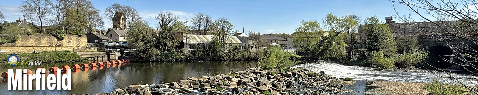
The town is on the River Calder.
Mirfield is on the Calder and Hebble Navigation.
The town has a range of shops and supermarkets. butchers, crafts, flowers, furnishings and other goods.
The town has a Post Office branch.
Mirfield has a bank.
The town has pharmacies.
Mirfield has several pubs.
A choice of cafes and pub food is available in Mirfield.
Takeaway food outlets in the town include fish and chips, chinese, curries, pizzas, burgers, kebabs, sandwiches.
The town has a library.
Mirfield has schools.
Places of worship: Anglican, Catholic, Methodist, other.

Travel


Mirfield Station

Mirfield station Station Road

1 Eastbound
Ravensthorpe 4 - Dewsbury 12 - Batley 15 - Morley 20 - Cottingley 24 - Leeds 32 - Selby 51 - Brough 1hr 16 - Hull 1hr 30
Ravensthorpe 4 - Dewsbury 5 - Batley 8 - Morley 14 - Cottingley 18 - Leeds 25
Wakefield Kirkgate 14 - Normanton 18 - Castleford 24 - York 49 ⁗ 4
Wakefield Kirkgate 16-26 - Pontefract Monkhill 31-38 - Doncaster 58 - 1hr 9min - London 2hr 42min - 2hr 51min(2) 3 Westbound
Deighton 5 - Huddersfield 9 - Slaithwaite 14 - Marsden 20 - Greenfield 27 - Mossley 31 - Stalybridge 36 - Manchester Piccadilly 40-52
Brighouse 8 - Sowerby Bridge 17 - Mytholmroyd 23 - Hebden Bridge 28 - Todmorden 39 - Walsden 42 - Littleborough 48 - Smithy Bridge 51 - Rochdale 56 - Manchester Victoria 1hr 10min (*49) - Wigan NW 1hr 53min (*) .
⁗ 4
Brighouse 6 - Halifax 16 - Low Moor 23 - Bradford 3116 - typical fastest journey times in minutes.
(*) - faster journey usually available via change of trains at Huddersfield.
Red - stations in West Yorkshire ticket area.

- no Sunday service.

- only 4 Grand Central trains daily. Not all trains stop at Pontefract.

Limited accessibilty - platforms are accessed by steps. Platform 3 is the only one with a ramp and this is at the station car park access. Platform 1 and 2 entrance is from steps within the station underbridge and platform 3 is accessed by steps at the far end of the bridge from Mirfield town centre or via car park road and ramp.

Express trains - Trains other than those listed above pass through platforms at Mirfield without stopping. Stand clear of the platform edge. These trains may be caught by travelling first to Huddersfield or Dewsbury or Leeds.

Station managed by: NORTHERN.   Operator/s: GRAND CENTRAL, NORTHERN, TRANSPENNINE EXPRESS.

NATIONAL RAIL - Departure and station info
External link to National Rail live departure board for services at this station (opens in new tab).


Bus travel

Buses operate on routes with stops through the Mirfield area. In Mirfield town centre, stops in Huddersfield Road near Ings Grove Park offer the best opportunity for inter-connection to another bus route. Stops in Huddersfield Road near to Station Road are served by some routes and have the nearest 5 minutes walk to Mirfield station.

Destinations include Kirkheaton 18, Dewsbury 20, Hartshead 23, Huddersfield 29, Heckmondwike 33, Cleckheaton 49, Bradford 55 ¡ , Leeds 1hr 18min1hr 18min - typical fastest bus journey times in hours/minutes.
Red - places in West Yorkshire ticket area.
¡ - One schoolday service only

Road travel

Mirfield can be reached via the A644


Places to Visit

Oakwell Hall and Country Park

Nutter Lane, Birstall
Oakwell HallOakwell Hall is a splendid grade I listed Elizabethan Manor house in an extensive country park near Birstall and around 4 miles north-north-west of Dewsbury. The house was built in 1583 by John Batt and is furnished as the family home in the late 17th century and is surrounded by gardens reflecting the garden styles of that period. Oakwell Hall was the inspiration of Fieldhead in Charlotte Brontë's novel "Shirley". The hall also has information on the English Civil War battle of Adwalton Moor, the site of which is a walk of about a mile from the hall. The Hall is surrounded by a 110-acre country park which includes woodland, farmland and a reclaimed colliery site. There are trail-marked paths around the park which includes ponds and nature information boards. There is also a visitor centre at the hall, a gift shop, playground and nature trail. There are car parks for both the house and the country park, accessed from Nutter Lane, Birstall. The hall is owned and maintained by Kirklees Council.
Find out more at the  Kirklees Council - Oakwell Hall and Country Park web pages
with further information at the  Friends of Oakwell Hall and Country Park website.
Locate on map:  Oakwell Hall


Spen Valley Greenway

Dewsbury to Oakenshaw
The Greenway is a disused railway route which once provided Bradford with a direct and faster route to other parts of Yorkshire and towards London as well as connecting the densely populated areas of Cleckheaton, Liversedge and Heckmondwike with major towns and cities. Today it is a pleasant green corridor providing an escape from the mass of traffic on the poor local road network increasingly pressured by a growing need to commute to big cities. The Greenway offers views towards distant moors and is home to a number of sculptures including a flock of sheep made from industrial scrap and a circle of 40 giant steel hoops. The traffic-free route forms part of Route 66 of the National Cycle Network, providing a gentle ascent from the edge of Dewsbury to Oakenshaw on the outskirts of Bradford.


National Coal Mining Museum for England

National Coal Mining Museum for EnglandNational Coal Mining MuseumWakefield Road, Overton
The National Coal Mining Museum for England is mid-way between Wakefield and Huddersfield, about 6 miles from each, on the main A642 road at Overton. It is also around 10 miles from Barnsley and just under 5 miles from Dewsbury. The former Caphouse Colliery has exhibits showing the history of mining in the Yorkshire coalfield and beyond. The museum also offers the chance to don a miner's helmet to take an underground tour down the mine. The tour takes about an hour and shows the changes in mining and conditions in the pit through its history. There's also chance to meet pit ponies, to take a trip on a colliery railway, to walk its nature trail or relax with food or a drink in its cafe.
More details at the  National Coal Mining Museum website.


Whistlestop Valley formerly Kirklees Light Railway

Shelley station - Kirklees Light RailwayKirklees Light RailwayPark Mill Way, Clayton West, near Huddersfield
Whistelstop Valley is a rebranding of the Kirklees Light Railway, a 15-inch-gauge light railway on the trackbed of the former Clayton West branch line from the Huddersfield-Penistone-Sheffield line. The branch had survived the Beeching axe of the 1960s but eventually closed to coal traffic in 1979 and passengers from the large commuter villages of Skelmanthorpe and Clayton West in 1983. Work began to create the new 15-inch-gauge light railway from Clayton West in 1991 and was completed along the full 3.5 miles to Shelley in 1997. The line operates most weekends and on weekdays at certain times of the year. Six steam locomotives and two diesel locomotives are used on the line, some built specially for the railway while others have seen previous service at seaside railways such as the Fairbourne Railway in Wales and Cleethorpes Coast Light Railway in North East Lincolnshire. Special occasions have seen guest visits from other lines, including the Romney, Hythe and Dymchurch Railway in Sussex and the Ravenglass and Eskdale Railway in Cumbria. Santa Specials operate in December. The railway is based at Clayton West where there is a cafe, play area, picnic area, miniature railway, gift shop and toilets. At the Shelley end of the line there is also a cafe, play area, picnic area and toilets. There is no interchange with the adjoining main line at KLR's Shelley station, but there is a waymarked walk to the station from Shepley, taking about 20 minutes. The KLR's intermediate stations at Skelmanthorpe and Cuckoo's Nest provide access to a good network of paths for walkers, Skelmanthorpe station being a short walk from the village. The railway marks its 30th year in 2021 with rebranding as Whistlestop Valley and traditional train tickets replaced with Big Adventure tickets if wanting a train ride as well as access to all facilities like the cafe and picnic area, activity space and a jumping pillow timetabled to arrive in August 2021.

More information at the  Whistlestop Valley website.


Yorkshire Sculpture Park

West Bretton
The Yorkshire Sculpture Park is the UK's leading open-air sculpture gallery, situated at West Bretton, between Barnsley, Huddersfield and Wakefield. Set in around 500 acres of beautiful parkland within the Bretton Estate adjoining Bretton Hall, the Yorkshire Sculpture Park offers what is probably the finest outdoor exhibition space in the country for modern and contemporary sculpture, attracting regional, national and international exhibits. The museum also has indoor exhibition spaces, cafes and shops. The museum car parks are accessed off the A637 Huddersfield Road between West Bretton and junction 38 of the M1. From 2020, the Yorkshire Sculpture Pak has introduced an admission charge with advance booking required. Parking is included in the admission fee.

More information at the  Yorkshire Sculpture Park website.
Find on map:  Yorkshire Sculpture Park


Peak District National Park

The vast area of the Peak District National Park extends into southern and western parts of the Kirklees district near Holme, Meltham and Marsden. Buses run from Holmfirth into the National Park, which stretches from Yorkshire into Derbyshire and beyond. For more details see our Peak District page.


Emergency services

West Yorkshire Police  West Yorkshire Police website.

West Yorkshire Fire and Rescue Service  West Yorkshire Fire and Rescue Service website.

Yorkshire Ambulance Service NHS Trust  Yorkshire Ambulance Service NHS Trust website.


Local government


Civil parish council

Mirfield Town Council
Provides some local services in the area.
Link to council website:  Mirfield Town Council


Metropolitan district council

Kirklees Council

Kirklees Council covers a large metropolitan district based in Huddersfield but also covering well over 100 towns and villages.

They include those in the former county borough of Huddersfield, the former boroughs of Dewsbury, Batley and Spenborough (based in Cleckheaton), the former urban districts of Heckmondwike and Colne Valley (based in Slaithwaite and also including Marsden) and the five large civil parishes created from former urban districts in Holme Valley (around Holmfirth), Denby Dale, Kirkburton, Meltham and Mirfield. Areas other than the latter five are without town or civil parish councils. Part of the district is in the Peak District National Park.

Kirklees Council is made up of 69 councillors with three councillors per ward in 23 wards. Councillors are elected for four-year terms with one-third involved in elections in three out of four years. Councillors elect a Mayor and Deputy Mayor of Kirklees each year.


Link to  Kirklees Council website.

Political composition after May 2024 election:

2291510643 KCIG
69 members KCIG = Kirklees Community Independents Group


See our Yorkshire.guide Gazetteer for more about the  Kirklees metropolitan district and places within it.

County strategic authority

West Yorkshire Combined Authority
Covers some combined services of the five metropolitan district councils of West Yorkshire -  Bradford,  Calderdale,  Leeds,  Kirklees and  Wakefield — which were at one time provided by a West Yorkshire metropolitan county council, with the addition of the non-contiguous unitary authority area of the City of  York council as well as the unelected Leeds City Region Enterprise Partnership. Since 2021 it has operated with an elected mayor as chairman and decision-maker for some responsibilities. These include transport, housing and planning and finance powers. The responsibilities also include those of Police and Crime Commissioner, a role substantially delegated to an appointee deputy mayor.

Elected mayor: Tracy Brabin Labour & Cooperative
 West Yorkshire Combined Authority website.


Police and Crime Commissioner

The Police and Crime Commissioner for West Yorkshire
This role has become one of the many responsibilities of the West Yorkshire elected mayor since May 2021.

 West Yorkshire Combined Authority website.


Fire Authority

West Yorkshire Fire Authority
The fire authority is made up of elected members of each of the five metropolitan district councils of West Yorkshire - Bradford, Calderdale, Leeds, Kirklees and Wakefield.
 West Yorkshire Fire Authority web pages.


Parliamentary constituency

Spen Valley
Elected MP: Kim Leadbeater Labour

National government region

Yorkshire and the Humber

Ceremonial county

West Yorkshire

Historic

-1974 Within the West Riding of Yorkshire


Also in Yorkshire.guide

 New    Places to visit    Gazetteer   


Yorkshire.guide - a dotguide.co.uk website. Made in Yorkshire UK   |  Terms of use  |  Privacy policy  with  No cookies  |  Contact  |