Yorkshire A to Y
Gazetteer
Calderdale metropolitan district X
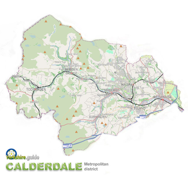 Calderdale metropolitan district is one of five very large metropolitan authorities which make up West Yorkshire, it includes the westernmost parts of the county, extending on to the high moorland of the South Pennines above the steep-sided upper Calder Valley.
Halifax is the administrative town of the metropolitan district, which was created in 1974, including other towns and villages as well as many remote hamlets.
Calderdale covers a total area of around 140 square miles (364 sq km)^, making it the fourth-largest of the five West Yorkshire metropolitan districts by area, although only a marginally smaller area than the neighbouring Bradford district and about 10 square miles more than Wakefield metropolitan district. As with all of Yorkshire's metropolitan districts it is a larger area than any metropolitan district area outside Yorkshire.
Calderdale's population of around 206,600* is the lowest of the five West Yorkshire districts, accounting for about 11% of the county population. Calderdale has a similar size population to the City of York unitary authority area.
Calderdale has boundaries with the Bradford and Kirklees districts of West Yorkshire. It also has boundaries with the Rochdale and Oldham districts of Greater Manchester and Rossendale and Pendle districts of Lancashire.
^ Area figure from ONS Standard Area Measurements 2022 (converted from hectares).
* Population figure from Census 2021.
Contains public sector information licensed under the
 Open Government Licence v3.0.
Places in the Calderdale metropolitan district are:
 Bailiff Bridge Barkisland
 Brighouse
 Clifton Coley Cornholme Cottonstones Cragg Vale Elland
 Greetland Halifax
 Hebden Bridge
 Heptonstall Hipperholme Holywell Green Hove Edge Illingworth Lightcliffe Luddenden Luddenden Foot Lumbutts Lydgate Mankinholes Mill Bank Mixenden Mount Tabor Mytholmroyd Northowram Ovenden Portsmouth Rastrick Ripponden
 Rishworth Shelf Southowram Sowerby Sowood Sowerby Bridge
 Stainland Todmorden
 Triangle Wainstalls Walsden Warley Town West Vale
We continue to add more villages to our A to Y gazetteer and the above may not yet list all places in Calderdale metropolitan district