Knottingley
West Yorkshire
Knottingley is 10 miles east of Wakefield city centre, 3 miles east-north-east of Pontefract, 4 miles east-south-east of Castleford and also 4 miles west of Eggborough in North Yorkshire.
The town stretches for around two miles alongside the River Aire and Aire and Calder Navigation.
Knottingley has a long history, being a village named in the medieval Latin of the Domesday Book survey of 1086 as Notingeleia. Knottingley's parish church, dedicated to St Botolph, owes much of its present style to Victorian rebuilding, but includes the wall of a Norman chapel built around 1100.
Knottingley grew as an inland port on the River Aire until navigation canal sections to Leeds were built in the early 18th century.
From the Victorian era, Knottingley became a centre for glass production and glass bottle making continues to be one of the main industries in the town.
Over a 50-year period from the 1960s, Kellingley Colliery produced coal just to the east of Knottingley. It was the last deep coal mine in the UK when it closed at the end of 2015.
Knottingley is close to the junction of
 Town features
 The town is on the River Aire.
 Knottingley is on the Aire and Calder Navigation.
  The town has pubs and social clubs.

 The town has a range of shops and supermarkets.
 The town has Post Offices.
 The town has pharmacies.
 Pub food is available in Knottingley.
 Takeaway food outlets in the town include fish and chips, chinese, curries, pizzas, sandwiches.
 Places to stay in Knottingley include hotel accommodation.
 The town has a visiting mobile library - at Morrisons for 20 mins every six weeks.
 Knottingley has schools.
 Knottingley has a town hall - Knottingley Town Hall Community Centre
 Places of worship: Anglican, Catholic, Methodist, other.
 Travel
Bus travel
The town has buses to neighbouring towns and villages.  Knottingley station
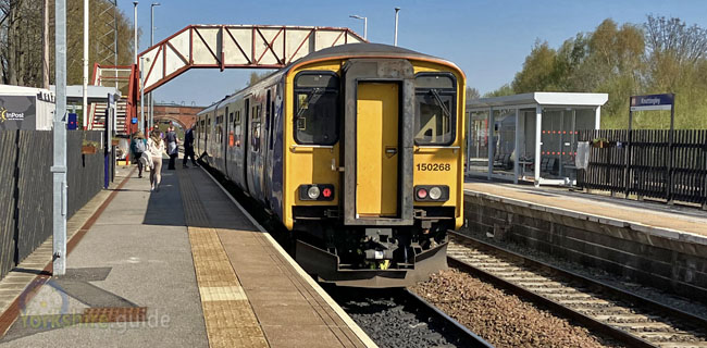 Station managed by: NORTHERN. Operator/s: NORTHERN.
  NATIONAL RAIL - Departure and station info
External link to National Rail live departure board for services at this station (opens in new tab).
 Road travel
Knottingley can be reached via the A645 B6136 Places to Visit
 Sandal Castle
Manygates Lane, Sandal Magna, near Wakefield, West Yorkshire
About two miles south of the city centre, the ruins of the medieval motte and bailey castle are freely open to the public and overlook the River Calder and the city. Some walkways at the castle, including steps to the keep, have recently been undergoing renovation and repairs following a £700,000 investment by Wakefield Council. The castle stood just above the site of the War of the Roses Battle of Wakefield in December 1460. Its damage, however, was ordered by Parliamentarians after the surrender of a Royalist garrison there in October 1645 during the English Civil Wars. More information at the  Wakefield Council - Sandal Castle
Wakefield Council - Sandal Castle Find on map:  Sandal Castle
Sandal Castle The Hepworth, Wakefield
Gallery Walk, Wakefield
A modern building next to the River Calder in Find out more at The Hepworth website.
The Hepworth Find on map: The Hepworth, Wakefield
The Hepworth, Wakefield National Coal Mining Museum for England
The National Coal Mining Museum for England is mid-way between
More details at the
National Coal Mining Museum Yorkshire Sculpture Park
West Bretton
The Yorkshire Sculpture Park is the UK's leading open-air sculpture gallery, situated at More information at the Yorkshire Sculpture Park website.
Yorkshire Sculpture Park Find on map: Yorkshire Sculpture Park
Yorkshire Sculpture Park Nostell
off Doncaster Road, Wragby , near Wakefield
The site of a medieval priory, Nostell features a mid-18th century Palladian-style house which has been described as an architectural masterpiece. It includes interiors added by Robert Adam and furniture by Yorkshire-born furniture designer Thomas Chippendale. The house, 6 miles south-east of More information can be found on the National Trust - Nostell web pages.
National Trust - Nostell Pontefract Castle
Castle Garth, Pontefract
Once the most impressive castle in Yorkshire, Pontefract Castle has been a ruin for nearly 380 years. It is believed to be the place where King Richard II died in 1400, the king having been imprisoned there in 1399. The castle was referred to (as Pomfret) in William Shakespeare's play Richard III as the place where Richard II was 'hack'd to death', although many historians put starvation as the likely cause. Mystery still surrounds the death as there were also stories of Richard's escape to Stirling in Scotland. The castle was visited in August 1541 by King Henry VIII with his queen of the past year, Catherine Howard, and also Thomas Culpeper. Culpeper was at the end of that year beheaded in London for his alleged adultery with the queen, who was herself executed a few weeks later. Pontefract Castle was a royalist stronghold in the English Civil War and was beseiged several times by Parliamentarian forces before its remains were destroyed in 1649. Low and excavated sections of the castle's once formidable walls and towers and parts of the cellars of the castle are all that remain today. The castle is managed by Wakefield Council. More information at the Experience Wakefield - Pontefract Castle website.
Experience Wakefield - Pontefract Castle Find on map: Pontefract Castle
Pontefract Castle Fairburn Ings
Near FairburnSituated 2 miles north-east of Castleford (3.5 miles by road), the Royal Society for the Protection of Birds reserve at Fairburn Ings offers hides, trails and a visitor centre. It has a variety of birdlife habitats, including lakes, woodland and wet grassland with resident and migrating birds depending on the season. The visitor centre is open each day except Christmas Day. The reserve holds events and discovery days through the year and there are also opportunities for pond-dipping.
 Emergency services
West Yorkshire Police West Yorkshire PoliceWest Yorkshire Fire and Rescue Service
West Yorkshire Fire and Rescue ServiceYorkshire Ambulance Service NHS Trust
Yorkshire Ambulance Service NHS Trust Local government
Metropolitan district council
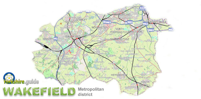 Wakefield Council
Wakefield Council covers an area extending many miles beyond the city of
The council is made up of 63 councillors elected 3 per ward across 21 wards. Elections held in 3 in every 4 years elect one councillor per ward for 4-year terms.
Political composition after May 2024 election:
63 members
Link to Wakefield Council website .
Wakefield CouncilCounty strategic authority
West Yorkshire Combined AuthorityCovers some combined services of the five metropolitan district councils of
 Bradford
 Calderdale
 Leeds
Leeds Kirklees
 Wakefield
 York
YorkElected mayor:
West Yorkshire Combined AuthorityPolice and Crime Commissioner
The Police and Crime Commissioner for West YorkshireThis role has become one of the many responsibilities of the West Yorkshire elected mayor since May 2021.
West Yorkshire Combined AuthorityNational government region
Yorkshire and the HumberFire Authority
West Yorkshire Fire AuthorityThe fire authority is made up of elected members of each of the five metropolitan district councils of West Yorkshire - Bradford, Calderdale, Leeds, Kirklees and Wakefield.
West Yorkshire Fire AuthorityParliamentary constituency
Pontefract, Castleford and KnottingleyElected MP: