Malham
North Yorkshire
It has for many years attracted tourists, walkers and geographers as the location of some of the country's most magnificent limestone scenery.
Malham is 5 miles of north of Coniston Cold (5.5 miles by road), 5 miles west of Settle (6.5 miles by road), 6 miles north-north-west of Gargrave (7 miles by road), 6 miles east of Grassington (11 miles by road), 8 miles south-west of Kettlewell (14 miles by road), and 9 miles north-west of Skipton (11 miles by road).
Malham is in the
• The Watlowes dry valley about 1.5 miles north of the village.
• Malham Tarn, a glacial lake and National Trust nature reserve 3 miles north of Malham.
• Janet's Foss a small but picturesque waterfall on the Gordale Beck falling into a natural pool in woodland about a mile's walk to the north-east of Malham.
The village hosts the Malham Show, an agricultural and country show each August.
The limestone pavements at the top of Malham Cove were used in a scene from the film Harry Potter and the Deathly Hallows Part 1.
There is evidence of people living at Malham Tarn dating back to the Mesolithic era and a Roman camp near to the Gordale Back about 2.5 miles north-east of the village, while Malham appeared in two entries in the Domesday Book of 1086 as Malgun.
 Village features
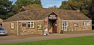
 The village is in the Yorkshire Dales National Park. (See National Park Centre below.)
 Malham is on the Pennine Way long distance trail.
 Malham Beck flows through the village and the River Aire starts just south of the village.
 Malham's two historic inns are close to the centre of the village. The Buck Inn dates from 1874 and is on the site of an even older coaching inn. The Lister Arms is a modernised old inn, carrying a date of 1723.
 Malham has a small selection of shops selling gift and souvenir items and a shop selling outdoor wear.
 Malham has a range of places to eat, including cafes, a hotel with bistro at Beck Hall and two inns with varied menus and food service. There is also the Victoria Inn at
  Malham Village Hall is in Cove Road.
 Malham Methodist Church is in Chapel Gate in the village.
  Malham Methodist Church
Malham Methodist Church The Anglican church is St. Michael the Archangel Church in
 Kirkby in Malhamdale UVA Primary School is between Malham and
  The village has a range of place to stay, including a hotel, inns with accommodation, bed and breakfast, a YHA hostel and campsites.
 There are public conveniences at the village car park at Chapel Gate and near the centre of the village at the junction of Cove Road and Chapel Gate.
(There are also toilets at the National Trust learning centre Orchid House on the north shore of Malham Tarn, which is about 3.5 miles walk from Malham village.)
 Information
 A
A Check opening times on the Yorkshire Dales National Park - Malham website.
Yorkshire Dales National Park - Malham 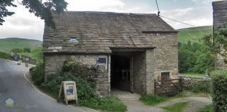 A renovated traditional Dales barn, Town Head Barn, near to where the footpath to Malham Cove branches from Cove Road, is a National Trust property which has at times been open during the summer to provide displays and leaflets about the Malham Tarn Estate.
More information at the
National Trust - Malham Tarn Estate  Travel
Bus travel
The West Yorkshire transport authority Metro publishes a useful information on travel to the Yorkshire Dales.
See: Metro - Yorkshire Dales web page.
Metro - Yorkshire Dales Dales and Bowland Community Interest Company, which organises weekend services, also has further information at the DalesBus website.
See: Dalesbus website.
 Road travel
Malham is reached by narrow country lanes, the nearest main road being the  Emergency services
North Yorkshire Police North Yorkshire Police North Yorkshire Fire and Rescue Service
North Yorkshire Fire and Rescue Service Yorkshire Ambulance Service NHS Trust
Yorkshire Ambulance Service NHS Trust  Local government
Parish council (civil parish)
Kirkby Malhamdale Parish CouncilKirkby Malhamdale Parish Council includes the grouped parishes of Malham, Malham Moor,
Link to dedicated Kirkby Malhamdale Parish Council page at malhamdale.com
Kirkby Malhamdale Parish Council Unitary authority
The North Yorkshire Council is a new unitary authority formed from the previous County Council from April 1, 2023. It covers the existing county duties including highways, schools, libraries and transport planning over an area of 3,109 square miles while also taking over the responsibilities of the seven huge district authorities also created in 1974 — Craven, Hambleton, Harrogate, Richmondshire, Ryedale, Scarborough and Selby — these including local planning, waste collection, street cleaning, parks and car parks, housing and markets serving a population of around 615,500*.
Councillors were elected to the County Council in 2022 and continue as councillors of the new North Yorkshire Council unitary authority. There have been a few by-elections to fill councillor vacancies since then.
Places in  North Yorkshire
North Yorkshire Link to council website: North Yorkshire Council
North Yorkshire Council Open Government Licence v3.0 Political composition:
Source North Yorkshire Council (June 2026) reflecting some party allegiance changes since election.
Strategic authority
York and North Yorkshire Combined AuthorityThe York and North Yorkshire Combined Authority was created in December 2023 combining the unitary authority of York and the unitary authority of North Yorkshire — that created in April 2023 after the abolition of the county authority and its seven district authorities. The combined authority will run some functions under the new mayor elected in May 2024 as part of the government's so-called "Devolution deal" which ties the availablity of funding to the new governance arrangements. As well as having powers over housing development, transport and boosting skills and education across the 3,214 square miles of York and North Yorkshire, the elected mayor also takes on the role and functions of the Police, Fire and Crime Commissioner across the area.
Elected mayor:
York and North Yorkshire Combined Authority Police, Fire and Crime Commissioner
Police, Fire and Crime Commissioner North YorkshireCovers the county of
 City of York Police, Fire and Crime Commissioner North Yorkshire
 Parliamentary constituency
Skipton and RiponElected MP:
National government region
Yorkshire and the HumberCeremonial county
North YorkshireHistoric
Also in Yorkshire.guide
Also in the former Craven district: Airton
Home Travel